|
作者:羅斯•偉納
2002年4月22日
這裡是厄瓜多的火山、海拔16,500英呎的陡峭斜坡上,法國冰河學家伯納德•法蘭古優雅地在冰塊和尖銳的碎石間移動,突然在一塊漆了藍色字母的卵石前面停了下來。
「我七年前第一次到這裡時,這裡是冰川的終點。」法蘭古說著,似乎對冰冷的毛毛雨完全沒感覺,然後他又指著一個足球場以外的上坡處,那裡有一堵藍色的冰牆標明厄瓜多安提拉納冰川現今的終點位置。

思想家伯納德•法蘭古(照片提供:伯納德•普亞,厄瓜多國家氣象水文學院)
南美洲的所有冰川都面臨與安提拉納相同的命運:依據法蘭古的估算,15年後,這塊大陸上的所有小型冰川(約佔冰川總數的80%)都會消失。他應當清楚,身為法國官方研發學院的研究主任,研究熱帶冰川已有15年之久,使他成為該領域最具權威的專家之一。
「趨勢實在太明顯了,數據會說話,無人能與之爭辯。」法蘭古說。
數據真的十分驚人:1996到1998年間,安提拉納冰川倒退了100碼,面積縮減了8%。小冰川融化得更快,波利維亞的查卡塔亞冰川光是在1990年代中期,面積就縮減近半,體積則減少了三分之二。
冰川消失對於南美城市絕對不是好消息,因為他們終年都需依賴冰川提供水源和發電。例如厄瓜多的首都基多,其水源有一半來自安提拉納冰川。因為擔心水源的供應,基多市府已加入贊助法蘭古的安提拉納冰川監測計劃。「對我來說,冰川研究是氣候變遷的議題;對於厄瓜多政府來說,卻是經濟衝擊的問題。」法蘭古說。

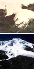
1994年(上圖)和2000年(下圖)的安提拉納冰川。(照片提供:伯納德•法蘭古,厄瓜多國家氣象水文學院)
厄瓜多政府有充分的擔心理由:基多另一半的水源來自「禿高原」,這是一種鋪滿厚厚植被的高海拔生態系統,如果冰川消失了,它也極可能會跟著消失。「我們知道,冰川是促成亞馬遜流域流動濕氣、形成降雨的原因,」基多市水利局局長艾德加•艾亞貝卡說,「禿高原可以像海綿般吸收大量雨水,然後慢慢釋放水分。我們要研究的是,冰川融化是否會使禿高原變成沙漠。」
後退!
我想實際了解南美洲冰川所發生的問題,所以跟著法蘭古及他的厄瓜多同事波利維•凱塞瑞,一同前往安提拉納進行監測。此行任務包括在冰川盡頭、和19,000英呎高的山頂進行測量。法蘭古的小組每隔一週去冰川調查,從基多出發車程約一小時半,甚為方便。最後一段是輪溝深陷的崎嶇山路,迤邐在開闊不毛的禿高原上,只有一群群山羊,和安提拉納白色晶瑩的火山錐擋在前頭。雄偉山勢的另一邊,地勢陡降到亞馬遜盆地,源自這一帶的水流進入巴西後再流入海洋。

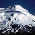
安提拉納冰川(照片提供:伯納德•法蘭古,厄瓜多國家氣象水文學院)
法蘭古在波利維亞和祕魯亦主持類似的研究小組,並希望能在印度成立另一個新專案;沿途我便問他,為什麼專攻熱帶地區氣候變遷這個主題,當大部分他的同行都將注意力放在北極或南極時。
「熱帶地區可能是除了極區以外,受氣候變遷影響最大的地方,」他指向就在附近的太平洋,那是著名的海洋暖化循環 -
聖嬰現象發生之處。「隨著聖嬰現象的頻率和強度增加,這些冰川也產生立即影響。」
雖然安地斯山脈的冰川從小冰期結束(約1870年左右)以來就一直後退,但其融化速度隨著1990年代發生聖嬰暖化現象而急遽上升(90年代剛好也是有史以來最熱的十年)。安提拉納冰川消退的速度,在這十年加快了七到八倍。(「小冰期」是學術用法)
【文章連載】
■消失在即 (上) (下)
全文與圖片詳見: http://www.gristmagazine.com/main
dish/wehner042202.asp
版權歸屬Grist Magazine,社團法人台灣環境資訊協會 (李眉君 譯,蘇崧棱 審校)
|
|
by Ross Wehner
22 Apr 2002
Even 16,500 feet in the air, perched on the steep slope of a volcano in Ecuador, French glaciologist Bernard Francou moves gracefully. Hopping among ice blocks and jagged rock debris, he stops suddenly before a boulder with blue letters painted on its surface.
"This is where the glacier stopped when I first came here seven years ago," Francou explains, oblivious to the cold and the drizzle. He then points more than a football field's distance uphill, where a wall of blue ice marks the present-day terminus of Ecuador's Antizana glacier.

The thinker: Bernard Francou. Photo: Bernard Pouyaud, Ecuador Instituto Nacional de Meteorologia e
Hidrologia.
All over South America, glaciers are meeting the same fate as Antizana: Within the next 15 years, all of the continent's small glaciers -- about 80 percent of the total -- will disappear, according to Francou. He should know: As director of research for the French government's Institute of Research and Development, Francou has been researching tropical glaciers for 15 years, making him one of the foremost experts in the field.
"The trend is so clear that you can't argue with the numbers," Francou claims.
And sure enough, the numbers are sobering: Between 1996 and 1998, the Antizana glacier shrunk 100 yards and lost 8 percent of its area. Smaller glaciers are melting even faster; the Chacaltaya glacier in Bolivia lost nearly half of its area and two-thirds of its volume during the mid-1990s alone.
The disappearance of these glaciers is bad news for South American cities that rely on them year-round for water and hydroelectricity. Quito, the capital city of Ecuador, gets fully half of its water from the Antizana glacier. Concerned about maintaining the supply, the municipality is jointly sponsoring Francou's monitoring of the Antizana glacier with the Institute for Research and Development. "For me, this glacier study is about climate change," explains Francou. "For the government of Ecuador, however, it is about economic impact."

Antizana glacier in 1994 (top) and 2000 (bottom). Photo: Bernard Francou, Eduador Instituto Nacional de Meteorologia e
Hidrologia.
The government has ample reason to be concerned: The other half of Quito's water supply comes from the paramo, a high-altitude ecosystem of thick, matted plants that will most likely disappear when the glaciers do. "We know that the glaciers cause passing moisture from the Amazon to fall as rain," explains Edgar Ayabaca, head of Quito's municipal water utility. "The paramo absorbs this water like a sponge and releases it slowly. What we are studying is whether the paramo will become a desert when the glaciers melt."
Retreat!
To see first-hand what is happening to South America's glaciers, I accompanied Francou and his Ecuadorian counterpart, Bolivar Caceres, on a monitoring trip to Antizana. Our mission was to take measurements both at the bottom of the glacier and at the mountain's 19,000-foot summit. Francou's team visits their glaciers every other week, so it's handy that Anizana is just an hour and a half drive from Quito. The last part of the journey is on a deeply rutted track that winds through acres upon acres of barren paramo, broken only by a herd of goats and the crystalline white cone of Antizana. On the other side of this massive volcano, the land drops down into the Amazon basin; water from the region drains into Brazil and beyond.

Antizana. Photo: Bernard Francou, Eduador Instituto Nacional de Meteorologia e
Hidrologia.
Along the way, I asked Francou, who has similar teams working in Bolivia and Peru and is hoping to start a new project in India, why he studies climate change in the tropics, when most of his colleagues focus on either the Arctic or the Antarctic.
"After the poles, the tropics are perhaps the area most heavily affected by climate change," he explains, pointing in the direction of the nearby Pacific Ocean where the cycle of ocean warming known as El Nino is born. "As the frequency and intensity of the El Nino cycles increase, these glaciers respond
immediately."
Although Andean glaciers have been retreating since the end of the Little Ice Age (around 1870), the pace of melting skyrocketed with the warm El Nino conditions of the 1990s -- which was also the hottest decade in recorded history. The Antizana glacier shrunk seven to eight times faster than normal during that 10-year span.
http://www.gristmagazine.com/main
dish/wehner042202.asp |
