|
作者:羅斯•偉納
登頂
車子開到路的盡頭後,我們穿上登山靴,開始攀登一大堆的冰磧石和大石塊,這是數百年來冰川推擠、堆積而成的。半小時的路程後,我們綁上鞋釘、爬上冰川,我看到數十支塑膠管以怪異的角度突出冰川表面。
「冰川由兩部分組成。」法蘭古到達第一根管子後開始解釋,「上半部由積雪組成,促使冰川往下滑;下半部的冰則融化導致冰川往後退。這兩個部分之間的分界線就是平衡線。」
科學家計算這些管子突出冰川表面的平均長度,就能判斷冰川下半部有多少雪融化了。另外一半的測量工作是在冰川上半部開挖雪坑(這是我們隔天要做的事),判斷今年累積了多少雪量。融化雪量和累積雪量之間的差值,稱為冰川的質量平衡。
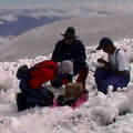
測量冰的厚度。(照片提供:羅伯•加賴爾,厄瓜多國家氣象水文學院)
檢查管子的同時,我們也在兩個裝滿儀器、活像NASA太空探測器的鋁製三角架旁邊停下來。「這兩個探測站可以告訴我們冰川的能量預算,」厄瓜多的科學家路易士•麥辛柯說,「這些儀器負責計算經由日光和風力進入冰川的能量有多少,經由蒸發和昇華離開冰川的能量又有多少。」這些資料儲存在小型硬碟中,這時麥辛柯拔出舊的,插入新的硬碟。
傍晚,我們在暴風雨中走下冰川,縮在吉普車中喝熱湯,然後準備就寢。身在15,850英呎的高山很久才能入睡,半夜法蘭古把我搖醒時,我根本沒辦法清醒。凌晨三點,我們已經經過昨天測量的那些管子,以及平衡線--融雪停止、開始積雪的點,從這裡腳底的冰開始變成雪。
這趟黎明前的艱苦路程讓人深深體會,想當個冰河學家絕不是件簡單的事,可是同行的所有人看起來都甘之如飴。我們必須在一片漆黑的稀薄空氣中辛苦的往上爬,路程似乎沒完沒了;同時還得抵抗每小時40英哩的狂風、及膝的深雪。每位考察隊隊員都用繩子綁在一起,以防有人掉進被雪掩蓋的裂隙中,我們前方的斜坡上交亙著許多這種裂隙。
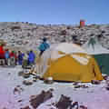
基地營(照片提供:羅伯•加賴爾,厄瓜多國家氣象水文學院)
5點左右,法蘭古突然停下,把滑雪杖插入雪中。他把綁住大家的繩子收攏,在風中對著我大聲吆喝:「雪實在太鬆了,有可能會發生雪崩。」他仔細查看頭頂上方的一片漆黑,「已經有太多人死於類似狀況。我們必須回頭。」
挖雪坑的工作就到此為止了,法蘭古安置好幾根管子,發誓下個月一定要跟凱塞瑞回來攻頂。此時雪線以上正在下大雨,似乎為造成冰川急遽退卻的大氣暖化現象做了最好的說明。
我們在9點左右回到營地,但在返回基多之前還有最後一項工作要做:檢查那兩個水文站。這些探測站記錄了冰川融水量,這是解開冰川行為模式的最後一道謎題。從管子、雪坑、能量站和水流收集而來的測量資料,可讓法蘭古和凱塞瑞建立準確到驚人的模式,描繪出安提拉納冰川上個月的變動,以及預測未來的動向。
悲哀的是,隨著模式越來越準確,所呈現的殘酷事實也越來越明顯:以目前氣候變遷的速度,熱帶冰川不用多久就會完全消失。我請法蘭古暫時拋開科學家的身分,問他對展現在南美高山上的「天啟」,有什麼個人想法?
似乎從來都不會累的他,低下頭,有一會兒,看起來好像累斃了,然後說道:「我花了大半輩子在高山裡,我本身也是一位登山家,對於這一切我深感悲哀。」
注:羅斯•偉納是西雅圖的自由作家和職業登山嚮導。
【文章連載】
■消失在即 (上) (下)
全文與圖片詳見: http://www.gristmagazine.com/main
dish/wehner042202.asp
版權歸屬Grist Magazine,社團法人台灣環境資訊協會 (李眉君 譯,蘇崧棱 審校)
|
|
by Ross Wehner
To Summit Up
When we arrived at the end of the road, we put on climbing boots and began to ascend a series of moraines, huge rock piles that were bulldozed into shape by the glacier in centuries past. After a half-hour walk, we strapped on crampons and climbed onto the glacier, where dozens of plastic tubes jutted out at odd angles from the icy surface.
"A glacier has two parts," explained Francou as he approached the first tube. "On the top half, snow accumulates and pushes the glacier downhill. On the bottom half, the ice melts and causes the glacier to shrink. The line between these two is the equilibrium line."
By calculating the average of the distance the tubes protrude from the surface of the ice, scientists can determine how much snow has melted from the bottom half of the glacier. The counterpart of this measurement -- which we planned to do the following day -- involves digging snow pits in the upper half of the glacier to determine how much snow had accumulated in the year. The difference between how much snow has melted and how much has accumulated is called the glacier's mass balance.
Measuring ice thickness. Photo: Robert Galliare, Eduador Instituto Nacional de Meteorologia e
Hidrologia.
In the course of checking tubes, we also stopped at two aluminum tripod-like structures laden with instruments and looking very much like NASA space probes. "These stations tell us the glacier's energy budget," explained Ecuadorian scientist Luis Maisincho. "These instruments calculate how much energy enters the glacier via sun and wind and how much leaves via evaporation and sublimation." Data is stored in a miniature hard drive, which Maisincho pulled out and replaced with a fresh unit..
Late that afternoon, we descended the glacier in a rain storm and huddled inside our Land Cruiser, where we drank hot soup before heading to bed. I found sleeping at 15,850 feet to be challenging, so I was not exactly jarred out of a deep slumber when Francou woke me at midnight. By 3 a.m., we had climbed past the tubes we'd measured the day before. We had also passed the equilibrium line -- the point at which melting stops and accumulation begins, where ice turns to snow underfoot.
There are definitely challenges to being a glaciologist, and all of them were readily apparent during our pre-dawn trek. We trudged endlessly uphill into the thinning air in pitch black, all the time working against 40 miles-per-hour wind gusts and knee-deep snow. Everyone on the expedition was roped together in case someone fell into the snow-covered crevasses that crisscrossed the slope in front of us.
Base camp. Photo: Robert Galliare, Eduador Instituto Nacional de Meteorologia e
Hidrologia.
Around 5 a.m. Francou stopped dead in his tracks on a steep slope and plunged his ski pole into the snow. He gathered the rope between us and shouted against the wind into my ear. "This snow is too unconsolidated and the risk of an avalanche is rising," he said, scanning the blackness above him. "Too many people have died in conditions like this. We must turn around."
So much for the snow pits; Francou placed a few more tubes and vowed to return the next month with Caceres to try again to reach the summit. It was now raining well above the snow line, which seemed a fitting illustration of the kind of atmospheric warming that is causing this glacier to retreat by leaps and bounds.
We were back in camp by 9 a.m., but before returning to Quito we had the final task of checking the two hydrological stations. These stations measure the amount of water melting from the glacier -- the final piece of the puzzle that is the glacier's behavior. Armed with the data from the tube measurements, the snow pits, the energy stations, and the water flow, Francou and Caceres can build a surprisingly accurate model of what the Antizana glacier has been up to in the last month --and what it will likely do in the future.
Sadly, as these models become more accurate, the grim truth they tell becomes more apparent: At the current pace of climate change, tropical glaciers are not long for this world. Talking for a moment to the human rather than the scientist, I ask Francou if he has a personal response to the apocalypse that is unfolding in the high mountains of South America.
The normally tireless man looks down for a moment, seemingly exhausted, and then says, "I have spent most of my life in the high mountains and I am also an alpinist. I regard all of this with much sadness."
-- Ross Wehner is a freelance writer and professional mountain guide based in Seattle, Wash.
http://www.gristmagazine.com/main
dish/wehner042202.asp |