美國魚類暨野生動物局(U.S. Fish and Wildlife Service)12日表示,荒野暨風景河川(Wild and Scenic Rivers)以及新的國家荒野保護區(National Wilderness Area)是阿拉斯加極地野保區在其15年保育管理計畫草案中的重要一章。
在歐巴馬政府計畫之下,阿拉斯加州正準備將開放野保區西邊邊界數百萬英畝州屬的極地讓開發業者探鑽石油與天然氣。
美國魚類暨野生動物局的全面保育計畫與環境影響評估初稿(Comprehensive Conservation Plan and Environmental Impact Statement)中,提出了六項長期管理的方案。
其中的一項方案建議會國會將忽拉忽拉河(Hulahula River)、空卡庫特河(Kongakut River)以及沼岔坎寧河(Marsh Fork Canning River)等河流劃定為荒野暨風景河川。
野保區的管理者佛斯(Richard Voss)表示,「我們的方案著重於建議可納入考慮的荒野暨風景河川,以及管理空卡庫特河。」
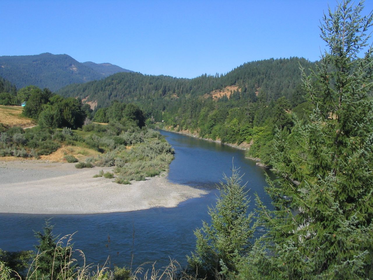
空卡庫特河位於布魯克斯山脈(Brooks Range)之北,景觀壯闊,範圍自山脈延伸至海岸平原,囊括了一系列獨一無二的地質奇景,將近四分之一造訪野保區的遊客的目的地都是空卡庫特河,流域全屬荒野區劃定地。
然而,計畫書指出,野保區的工作人員接獲許多通報,包括大批遊客擠滿遊船碼頭,遊客使用設施發生衝突;飛機飛越野保區上空頻率過於頻繁;營火堆;帳篷堆石,以及在遊客集中點與熱門的營地垃圾堆積;脆弱的河岸或凍原棲息地硬化或受到破壞;以及飛航機起降點增加。
為了進一步保護野保區,美國魚類暨野生動物局正考慮將三個區域列入劃定為國家荒野保護系統中(National Wilderness Preservation System),包括極地野保區海岸平原與布魯克斯山區。
上述受到考量的提案並不會影響現有的人類維生捕獵規範。
為了徵詢公眾對於所提六個方案的意見,該局於定案前正舉行一連串的公聽會以審視大眾意見,從這些意見徵詢的過程將會得到最終的建議方案。
阿拉斯加區保育規劃與政策處的天然資源規劃者塞姆(Sharon Seim)說道,「公眾參與是這份持續數年的全面保育計畫發展過程關鍵的一部分,我們也期待能在初稿計畫書中收到正式的公眾意見。」
塞姆說道,「我們想要知道人們喜歡什麼,不喜歡什麼,還有為什麼會這樣?我們想要知道我們遺漏了甚麼,還有我們該如何改善這份計畫。」
在野保區的野生動物與魚類物種包括了:北極熊、灰熊、棕熊與黑熊;狼、狼獾、貂,以及北極狐;北極旅鼠、麝牛、麋鹿以及達爾綿羊(Dall's sheep);矛隼、大麻哈鮭(chum salmon)以及國王鮭(Chinook salmon)、湖鱒、北嘉魚(Dolly Varden)、北極紅點鮭(Arctic char)、海豹、白鯨,還有偶爾出現的露脊鯨。
野保區也是成千上萬的候鳥築巢的棲息地。
中央北極圈的馴鹿群季節性地會在大陸分水嶺的北邊棲息,而分水嶺南邊的谷地則是豪豬、馴鹿群與北極馴鹿群過冬的地方。
這份全面保育計畫傳達了一個野保區的願景。「這片未經馴化的極地景致持續保存了生態多樣性以及其特殊價值。自然的歷程將會延續下去,傳統文化將隨季節與時序更迭茁壯;心智與體能的挑戰考驗我們的身心靈;我們藉由尊敬與自我約束來榮耀大地、野生生物,與原住民。透過負責任的管理,這片宏偉壯闊的荒野之地得以傳承給子子孫孫的世代。」
這片廣達9百萬英畝的北極國立野生生物保護區(Arctic National Wildlife Range)是在1960年代的時候建立的, 目的在於「為了保護獨一無二的野生生物、荒野,以及休閒價值…。」
在1980年代,阿拉斯加權益用地法案(Alaska National Interest Lands Conservation Act)將這片保育區擴增至1900萬英畝,並且重新命名為極地野保區,其中8百萬英畝的土地劃分為荒野區,並且有三條河流劃分為野生河道(Wild River)。
非營利組織野生物保衛者(Defenders of Wildlife)的執行副總克拉克(Jamie Rappaport Clark),同時也是柯林頓當政時期的美國魚類暨野生動物局主任,她表示極地野保區亟需加強保護。
 她指出,「政府需要將極地野保區裡脆弱的野生動物與天然資源看得比石油可能帶來的的暴利來得更重要,並且朝向建議設立荒野區的選項努力。如果魚類暨野生動物局能夠建議最終採納這個選項的話,將是跨進正式劃定野生保育極富意義的一步,而決定權則握在國會手中。」
克拉克說道,「若這個區域受到劃定,將會得到進一步的保護,包括嚴禁石油天然氣的開發行為,以及其他可能會干擾該區野生生態特徵的工業行為,都對保護野保區物種免於受到氣候變遷造成的威脅極為關鍵。」
野生物保衛者在12日公布的新研究報告指出,對於極地國家野保區裡38種哺乳類而言,其中有16種哺乳類動物必須立即加強保護措施,以確保它們能夠繼續生存下去。
報告指出,北極熊、北極狐、山貓以及馴鹿可能面臨嚴重的風險,因為北極的地貌已受到暖化的氣候以及工業發展入侵的影響而改變。
石油與天然氣開發商早對進駐極地國家野保區垂涎已久。
現在他們打的主意則是六月時由阿拉斯加州長帕內爾(Sean Parnell)宣布緊鄰野保區西邊邊界州屬土地的出租買賣。
州長計劃將於10月26日開放拍賣1470萬英畝的州屬極地租賃權供石油天然氣開發。
預計出租的土地包括了幾乎所有的中央極區州屬土地,範圍由坎寧河(Canning River)在極地野保區(ANWR)西邊的邊界,一直延伸到柯維爾河(Colville River)在阿拉斯加國家石油保護區(National Petroleum Reserve of Alaska)的東界。
出租的土地由北至南,將從北極海上三英哩的州屬水界拓展到布魯克斯山脈內陸120英哩之遠。租賃權並將包括所有沿著極地野保區以及阿拉斯加國家石油保護區的阿拉斯加州屬水體土地。
藉由探鑽州屬土地以及靠近阿拉斯加國家石油保護區以及極地野保區的水體,業者可能得以取得聯邦屬地底下蘊藏未經開發的原油。
這可能將是2011年在美國境內的最大宗租賃權買賣,這宗買賣包括了576塊地區:波弗特海(Beaufort Sea)海岸線沿線2百萬英畝;沿海北坡中部區域的510萬英畝;中央極區的布魯克斯山腳下共760萬英畝土地。
阿拉斯加石油天然氣管理處(Alaska Division of Oil and Gas)估計,預計出租的土地可能的原油蘊藏量約介於3百萬至6百萬桶之間,而天然氣含量則約介於24-44兆立方英呎之間。
美國魚類暨野生動物局宣稱,「氣候變遷在可預見的未來,預計將會持續影響野保區的資源以及相關的人類環境。」該局竟表示,「野保區實在沒有甚麼可以採取的行動」能管理氣候變遷造成的影響。
儘管如此,計畫初稿還在管理指引中加了氣候變遷的內容。野保區的工作人員將會監測以及研究氣候變遷,但是將依據不干預的立場進行,除了在有入侵性的物種威脅下,或在緊急情況下的管理,如公眾安全,受到威脅或瀕危物種,或生存資源。
克拉克表示,「早在石油與天然氣探鑽行動進來攪局之前,美國魚類暨野生動物局就已經接手四面楚歌的野保區生態價值保存這份艱鉅的任務。」
她指出,「將這片區域劃分為荒野保育地,保護土地上的野生生物以及天然棲息地不受帶來污染的石化燃料開發所威脅,將能提供野保區一個機會,強化野保區的功能,並且爭取到寶貴的時間來育養有生存危機的野生生物。」
除了公眾諮詢期外,該局也宣布了將在阿拉斯加舉辦一系列的公開會議,這些活動將由8月24日在費爾班克斯(Fairbanks)舉辦的魚類暨野生動物局開放日揭開序幕。詳細的活動日期與地點清單可參考以下連結:按此連結活動清單。公眾諮詢期將持續至2011年11月15日止。
The designation of Wild and Scenic Rivers and a new National Wilderness Area are central to a new 15-year draft conservation management plan for the Arctic National Wildlife Refuge in Alaska, the U.S. Fish and Wildlife Service said Friday.
The Obama administration's plan comes as the State of Alaska is preparing to open millions of acres of state-owned arctic lands on the western border of the refuge to an oil and gas lease sale.
The Fish and Wildlife Service's draft Comprehensive Conservation Plan and Environmental Impact Statement contains six alternatives for long-term management.
One alternative recommends that Congress designate the Hulahula, Kongakut, and Marsh Fork Canning rivers as Wild and Scenic Rivers.
"Our alternatives focus on potential wilderness and wild river recommendations, and management of the Kongakut River. The draft plan does not include a preferred alternative," said Refuge Manager Richard Voss.
The Kongakut River, on the north side of the Brooks Range, offers spectacular views from the mountains to the coastal plain; contains a variety of unique geologic features; receives nearly one-quarter of the documented visitors to the refuge; and its entire extent is in designated wilderness.
But, the plan says, refuge staff have received visitor reports of group crowding at boat launches; user conflicts; excessive over-flights; fire rings, tent rings, and human waste accumulations at concentrated access points and popular camp areas; hardening or impairment of fragile riparian and tundra habitats; and increased footprint of aircraft landing areas.
For further protection, the Service is considering designating three areas, including the Arctic Refuge coastal plain and the Brooks Range of mountains, for inclusion within the National Wilderness Preservation System.
None of the proposals under consideration would change existing protocols for subsistence harvest.
To get public opinion on the six options, the agency is conducting a series of public meetings and reviewing public comments before finalizing the plan, which will ultimately identify a preferred alternative.
"The involvement of the public is a critical part of the multi-year Comprehensive Conservation Plan development process, and we look forward to receiving substantive public input on the draft plan," said Sharon Seim, natural resource planner in the Alaska Region Division of Conservation Planning and Policy.
"We want to know what people like, what they don't like, and why," said Seim. "We want to know what we've missed and how we can make the plan better."
Wildlife and fish species on the refuge include: polar bear, grizzly bear, brown and black bears; wolf, wolverine, marten and Arctic fox; lemmings, muskox, moose and Dall's sheep; gyrfalcon, chum and Chinook salmon, lake trout, Dolly Varden, and Arctic char, seals, beluga whale, and an occasional bowhead whale.
The refuge offers nesting habitats for hundreds of thousands of migratory birds.
Much of the Central Arctic Caribou herd seasonally inhabits the area north of the continental divide, while the valleys south of the divide provide important wintering habitat for both the Porcupine Caribou herd and the Central Arctic herd.
The Comprehensive Conservation Plan expresses a vision for the refuge. "This untamed arctic landscape continues to sustain the ecological diversity and special values that inspired the Refuge's establishment. Natural processes continue and traditional cultures thrive with the seasons and changing times; physical and mental challenges test our bodies, minds and spirit; and we honor the land, the wildlife and the native people with respect and restraint. Through responsible stewardship this vast wilderness is passed on, undiminished, to future generations."
The Arctic Refuge was established in 1960 as the nine million acre Arctic National Wildlife Range "for the purpose of preserving unique wildlife, wilderness, and recreational values ..."
In 1980, the Alaska National Interest Lands Conservation Act enlarged the area to over 19 million acres, renamed it the Arctic National Wildlife Refuge, designated eight million acres of it as Wilderness and designated three Wild Rivers.
Jamie Rappaport Clark, executive vice president of the nonprofit Defenders of Wildlife and a former director of the Fish and Wildlife Service under President Bill Clinton, says the refuge urgently needs increased protection.
"The administration should put the well-being of the Arctic Refuge's vulnerable wildlife and natural resources before the interests of Big Oil and pursue a wilderness recommendation," she said. "A wilderness recommendation by the Fish and Wildlife Service "would be a meaningful step toward ultimately securing a formal wilderness designation, which can only be made by Congress."
"The enhanced protection afforded by such a designation, including a prohibition on oil and gas development and other industrial activities that would disturb the area's wilderness character, are critical to avoiding even greater peril to the survival of species on the refuge due to climate change," said Clark.
New research released Friday by Defenders of Wildlife shows that increased protection for the Arctic National Wildlife Refuge is critical to the survival of 16 of the refuge's 38 mammals.
The report warns that the polar bear, Arctic fox, lynx and caribou could face serious risks as the Arctic landscape is transformed by a warming climate and encroachment of industrial development.
Oil and gas developers have long desired to get into the Arctic National Wildlife Refuge.
Now they have their eyes on a lease sale of Alaska State lands on the western border of the refuge announced by Governor Sean Parnell in June.
The governor plans to open up 14.7 million acres of state owned arctic lands to an oil and gas lease sale on October 26.
The land to be leased comprises almost all of the central arctic state-owned land between the Canning River western border of ANWR to the Colville River eastern border of the National Petroleum Reserve-Alaska.
It will extend north to south from the Arctic Ocean three mile state waters boundary all the way to the foothills of the Brooks Range 120 miles inland. The leases will also include all the Alaska State waters land along the 10-02 Area of ANWR and the National Petroleum Reserve-Alaska (NPR-A).
By drilling on state land and waters adjacent to NPR-A and ANWR, developers may access untapped oil that lies beneath these federal lands.
It will potentially be the largest lease sale held in the United States in 2011 comprising 576 tracts including: two million acres along the Beaufort Sea coast; 5.1 million acres in the central coastal North Slope; and 7.6 million acres in the Central Arctic Brooks Range Foothills.
The Alaska Division of Oil and Gas estimates that the lease area could contain between three and six billion barrels of oil and 24-44 trillion cubic feet of natural gas.
Saying that "climate change is expected to continue to affect refuge resources and the associated human environment for the foreseeable future," the Service said there are "few actions the Refuge can take" to manage the effects of climate change.
Nevertheless, the draft plan adds a climate change component to the Management Guidelines. Refuge staff will monitor and study climate change, but will follow a process of non-intervention with the exception of invasive species or management emergencies such as public safety, threatened or endangered species, or subsistence resources.
"The Fish and Wildlife Service faces the daunting task of preserving the ecological values of this refuge under siege. And that's before the complications and damage posed by dangerous oil and gas drilling have even come into play," Clark said.
"Recommending the area as wilderness, and protecting its wildlife and natural habitats from dirty fossil fuel development," she urged, "provides an opportunity to strengthen the refuge and buy valuable time to sustain its threatened wildlife."
In addition to the public comment period, the Service announced it will hold a series of public meetings in Alaska beginning with an Open House in Fairbanks on August 24. Click here for a full list of dates and meeting locations. Public comments will be accepted through November 15, 2011.
全文及圖片詳見:ENS報導