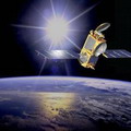
 美國太空總署與法國太空研究中心合資打造的海洋觀測衛星,20日早晨由凡登堡空軍基地正式發射,將在未來3年針對全球氣候變遷指標的海平面變化,進行完整的記錄。
此項衛星任務預計將傳回大量的新數據,提高對氣候和海洋預測的準確度。
「傑森2號」或所謂的「海洋表面地形任務」,是美國國家航空暨太空總署噴射推進實驗室、美國海洋暨大氣總署、法國太空研究中心和歐洲氣象衛星服務站共同合作的研究計劃。
這顆衛星將可提供地球上95%海洋的含蓋範圍,數據每10天更新1次,並以3公分(1.3英吋)的允差計算海平面的高度。
另外還包括海平面高度或海洋地形的測量、再現海洋洋流的速度和方向,以及讓科學家了解海洋中所儲存的太陽能。將洋流和能源儲存量數據做結合,將是推斷全球氣候變動的關鍵。
太空總署噴射推進實驗室資深科學家傅立倫(Lee-Lueng Fu)表示:「傑森2號將協助建立首次以數十年為單位的地球記錄,讓人類深入了解海洋在氣候變遷上所扮演的重要角色。新衛星所提供的數據,可以讓我們持續監控地球海平面的變化,而目前這領域中的預測模型仍具有極大的不確定性。」
其他國家也會依賴衛星所傳回的資料,來發展他們的科學研究計劃。
這些資料對於某些領域的運作也相當重要,包括澳洲發展中的海洋預測系統、藍芽無線、海洋安全、沿岸石油天然氣鑽探、測量地球海平面上升高度、追蹤如聖嬰現象此類大規模的海洋現象、海生哺乳動物在過度滋養的海洋渦漩中飼育情況,以及預測如雪梨荷巴特帆船賽這類運動競賽的洋流等等。
A new NASA-French space agency oceanography satellite was lofted into space from Vandenberg Air Force Base early Friday morning on a three year mission to record sea level, a vital indicator of global climate change.
The mission is expected to return a vast amount of new data that will allow greater precision in weather, climate and ocean forecasts.
Jason-2, or the Ocean Surface Topography Mission, is a joint venture between NASA's Jet Propulsion Laboratory, the U.S. National Oceanic and Atmospheric Administration, the French Space Agency, and the European Meteorology Satellite service.
The satellite will provide 95 percent coverage of the world's ice-free oceans, repeating its coverage every 10 days and measuring sea surface height with an accuracy of about three centimeters (1.3 inches).
Measurements of sea-surface height, or ocean surface topography, reveal the speed and direction of ocean currents and tell scientists how much of the Sun's energy is stored by the ocean. Combining ocean current and heat storage data is key to understanding global climate variations.
"OSTM/Jason 2 will help create the first multi-decadal global record for understanding the vital roles of the ocean in climate change," said project scientist Lee-Lueng Fu of NASA's Jet Propulsion Laboratory in Pasadena. "Data from the new mission will allow us to continue monitoring global sea-level change, a field of study where current predictive models have a large degree of uncertainty."
Other countries too are depending on the information the satellite will send back to Earth to develop their own scientific programs.
This information is also important for: Australia's evolving ocean forecasting system, BLUElink; sea safety and offshore oil and gas operations; measuring global sea level rise; tracking large-scale ocean-atmosphere phenomena like El Nińo and La Nińa and marine mammals feeding in nutrient-rich ocean eddies; and forecasting currents for sports events such as the Sydney-Hobart yacht race.
全文及圖片詳見: ENS


