 跨國研究團隊25日發表研究結果指出,南極冰棚下流過的溫暖洋流,是造成南極冰層冰損失的主因,此發現將使科學家對未來海平面上升能提出更精準的預測。
藉助美國太空總署(NASA)冰、雲、陸地高層衛星(Ice, Cloud, and land Elevation Satellite,簡稱 ICESat)所獲得的資料,再佐以電腦模型輔助,研究人員得以區分出由冰棚融化的兩大作用力:由海面下暖流導致的冰層下方融化、另一則是因暖空氣導致的冰棚上方融化。
研究計畫主持人、英國南極調查所(British Antarctic Survey)Hamish Pritchard表示:「無須靠夏天太陽融化冰川頂部的積雪,暖洋流由下方能融掉近非常大量的冰層。」他指出,「真正有趣的是,冰河對此現象的敏感度。有些冰棚一年變薄數公尺,導致冰河一年排出數十億噸冰至海中。這現象證明冰棚對減緩冰河速度的重要性;因為冰河提供冰床所需的冰,能控制住南極冰床流失。」
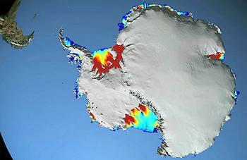
研究人員藉由安裝在ICESat上的雷射光儀器所蒐集的450萬筆雷射測距資料,繪製出幾乎涵蓋整個南極洲的浮動冰棚厚度變化,呈現了整個大陸的冰棚溶化趨勢。
在54個冰棚的地圖資料中,有20個冰棚(多數位於西南極洲)的冰層因下方流經的暖洋流而融化,進一步加速內陸向大海的冰川流動補注這些薄冰棚,使得更多的冰注入海中加速海平面上升。
在歷時5年的研究期間(2003年10月-2008年10月),研究發現這種肇因於海洋導致冰層變薄的驅動力,成為西南極洲冰床流失的最大及最迅速的主因。
這個研究是由分屬於英國的南極調查所(設於劍橋大學)、荷蘭的烏得勒支大學、美國加州大學聖地牙哥分校、及奧勒崗州非營利組織「地球與空間研究」(Earth and Space Research)的科學家們共同完成,成果發表於《自然》期刊上。
科學家們使用了由ICESat所蒐集450萬筆太空遙測資料的時間序列來繪製幾乎涵蓋整個南極大陸的浮動冰棚厚度變化地圖。他們量測了冰棚隨著時間的高度變化,並運用電腦模式來去除降雪等自然因素對冰層高度變化產生的影像。研究者也使用了潮汐模式來來推估潮汐對冰層高度變化的影響。
「這項研究呈現了太空遙測是研究地球現象的有利工具。」美國太空總署低溫層計畫(cryosphere program)科學家Tom Wagner說:「加上美國太空總署其他從重力回溯與氣候實驗(GRACE)自衛星雷達及飛機得來的陸冰研究資料,我們對於冰床的改變將會得到更全面的資訊,這些資訊將有助於估測海平面上升。」
 以往多半使用衛星雷達資料來推估冰棚及冰河的變化,不過雷射測距將更可更精準的偵測冰棚厚度隨時間的變化。這將更真實的呈現海岸地區的地貌。因為解析度較低的雷達難以感測浮動的冰棚與陸冰分界的基線(grounding line)。
ICESat是第一顆為了研究地球的極區所設計、並使用雷射測距技術的衛星。它的役期為2003年到2009年;繼任的ICESat-2衛星預定於2016年推出。NASA高達德太空飛行中心(Goddard Space Flight Center)科學家Jay Zwally表示,本研究揭露了我們對ICESat-2衛星升空的迫切需要;我們對於全球氣候變遷在極地產生的影響所知有限,沒有其他任何東西可像衛星遙測來監測這些變化。
本研究亦將發生在冰河底、冰棚及冰川加速區域風的運行所造成的改變,與觀測到的融冰現象連結。Pritchard說道,「研究顯示南極風因氣候變遷而改變,這影響了洋流的強度和方向,因而溫水在浮冰的下方呈現漏斗狀。這些研究和我們的研究結果都呈現南極的冰河因應氣候變遷而有急遽的改變。」
可以南極半島的例子來解釋風的影響。南極半島是南極洲上一個的狹長陸塊,陸塊方位朝向南美。本研究顯示半島上最大的冰棚變薄可以通過冰棚表面的夏季暖風造成融雪解釋。發生在南極半島海源性的融冰現象及夏天的融冰趨勢可以風的改變趨勢來解釋。
本研究是國際間為了進一步瞭解冰與氣候的交互作用,提供海平面上升更可靠的資料來源所進行的研究的一部份。
歐盟資助的「冰到海研究計畫」(ice2sea program)主持人David Vaughan表示,這份研究的主要貢獻在於清楚的呈現近年來南極的冰床失去冰的原因。但更重要的是,未來預測冰床變化的關鍵在於瞭解海洋。或許我們不該只從南極大陸的空中尋求答案,也應多瞭解環繞它的大海。
Warm ocean currents flowing beneath ice shelves are the main cause of recent ice loss from Antarctica, concludes a study by an international research team published today. The finding brings scientists closer to providing reliable projections of future sea level rise.
Using measurements from NASA's Ice, Cloud, and land Elevation Satellite, ICESat, in combination with computer models, the researchers were able to distinguish between warm ocean currents thawing the ice sheets from below and warm air melting them from above.
"We can lose an awful lot of ice to the sea without ever having summers warm enough to make the snow on top of the glaciers melt," said lead author Hamish Pritchard of the British Antarctic Survey based in Cambridge, UK. "The oceans can do all the work from below."
"What's really interesting is just how sensitive these glaciers seem to be," said Pritchard. "Some ice shelves are thinning by a few meters a year and, in response, the glaciers drain billions of tons of ice into the sea. This supports the idea that ice shelves are important in slowing down the glaciers that feed them, controlling the loss of ice from the Antarctic ice sheet."
Researchers used 4.5 million measurements made by a laser instrument mounted on ICESat to map the changing thickness of almost all the floating ice shelves around Antarctica, revealing the pattern of ice-shelf melt across the continent.
Of the 54 ice shelves mapped, 20 are being melted by warm ocean currents, most of which are in West Antarctica. There, inland glaciers flowing down to the coast and feeding into these thinning ice shelves have accelerated, draining more ice into the sea and contributing to sea-level rise.
This ocean-driven thinning is responsible for the most widespread and rapid ice losses in West Antarctica and the majority of Antarctic ice sheet loss during the five-year period of the study, October 2003 to October 2008, the study concludes.
Published in the journal "Nature," the study was carried out by scientists from the British Antarctic Survey, Utrecht University in Utrecht, Netherlands, the University of California in San Diego and the nonprofit research institute Earth and Space Research in Corvallis, Oregon.
To map the changing thickness of almost all the floating ice shelves around Antarctica, the team used a time series of 4.5 million surface height measurements taken by a laser instrument mounted on ICESat.
They measured how the ice shelf height changed over time and ran computer models to discard changes in ice thickness because of natural snow accumulation and compaction. The researchers also used a tide model that eliminated height changes caused by tides raising and lowering the ice shelves.
"This study demonstrates the power of space-based, laser altimetry for understanding Earth processes," said Tom Wagner, cryosphere program scientist at NASA Headquarters in Washington."
"Coupled with NASA's portfolio of other ice sheet research using data from our GRACE mission, satellite radars and aircraft, we get a comprehensive view of ice sheet change that improves estimates of sea level rise," said Wagner.
Previous studies used satellite radar data to measure the evolution of ice shelves and glaciers, but laser measurements are more precise in detecting changes in ice shelf thickness through time. This is especially true in coastal areas. Steeper slopes at the grounding line, where floating ice shelves connect with the landmass, cause problems for lower-resolution radar altimeters.
ICESat was the first satellite designed to use laser altimetry to study the Earth's polar regions. It operated from 2003 to 2009. Its successor, ICESat-2, is scheduled for launch in 2016.
"This study demonstrates the urgent need for ICESat-2 to get into space," said Jay Zwally, ICESat project scientist at NASA's Goddard Space Flight Center in Greenbelt, Maryland. "We have limited information on the changes in polar regions caused by climate change. Nothing can look at these changes like satellite measurements do."
The research links changes in wind patterns with the observed increase in melting that occurs on the underside of a glacier or ice shelf and glacier acceleration.
"Studies have shown Antarctic winds have changed because of changes in climate," Pritchard said. "This has affected the strength and direction of ocean currents. As a result warm water is funneled beneath the floating ice. These studies and our new results suggest Antarctica's glaciers are responding rapidly to a changing climate."
A different pattern is evident on the Antarctic Peninsula, the long stretch of land pointing towards South America. The study found thinning of the largest ice shelf on the peninsula can be explained by warm summer winds directly melting the snow on the ice shelf surfaces.
The patterns of widespread ocean-driven melting and summer melting on the Antarctic Peninsula can be attributed to changing wind patterns.
This research is part of international efforts to improve understanding of the interactions between ice and climate in order to improve the reliability of sea-level rise projections.
Professor David Vaughan, leader of the EU-funded ice2sea program, said, "This study shows very clearly why the Antarctic ice sheet is currently losing ice, which is a major advance. But the real significance is that it also shows the key to predicting how the ice sheet will change in the future is in understanding the oceans. Perhaps we should not only be looking to the skies above Antarctica, but also into the surrounding oceans."


