恢復北鹹海生態的哈薩克奇蹟 | 環境資訊中心
國際新聞

恢復北鹹海生態的哈薩克奇蹟

2008年08月05日
摘譯自2008年8月1日ENS哈薩克,阿斯塔那報導;范仕穎編譯;蔡麗伶、禾引審校

哈薩克Kok-Aral水壩一景。圖片來源:世界銀行在20世紀的後半期間湖面縮減到原來1/4大小的中亞北鹹海,現在水已經重新回流其中,魚類、海鳥和爬蟲類也開始在鹹海和其周邊重新繁衍。

雖然海岸是由兩個國家所共有,分別是位於北方的哈薩克,以及位於南方的烏茲別克。兩條大河注入鹹海灣,入海之前由多山的阿富汗、塔吉克、吉爾吉斯共和國,也流經的烏茲別克、哈薩克和土庫曼的平原。

鹹海在60年代開始縮減,源於蘇聯為了種植棉花和稻米而大量抽乾了入鹹海的兩條河,Syr Darya和Amu Darya的河水,導致至1996年,鹹海的水量減少了3/4,也嚴重破壞了周遭的環境和沿海漁村的傳統漁業。

本週哈薩克政府宣布了其耗資2.6億美元的拯救計畫已有成效,該計畫是在2001年由哈薩克總統納瑟拜耶夫(Nursultan Nazarbayev)所推動,由世界銀行所支持。根據哈薩克外交部於7月30日的聲明表示,該計畫自2003的測量以來已經增加了30%的海面積。

北鹹海面積已由2003年的2550平方公里(985平方英里)增加到2008年的3300平方公里(1275平方英里)。而海水深度也從30公尺(98英尺)增加到42公尺(138英尺)。

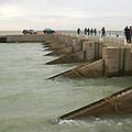
為了增加留入北鹹海的水量,哈薩克政府和世界銀行耗資8550萬美金建造了Kok-Aral水壩,其中世界銀行提供了6500萬的貸款。

長達13公里(8英里)的水壩在2005年完成,將鹹海一分為二:較小的北鹹海和較大、較鹹、污染情形也較嚴重的南鹹海。自從水壩完成之後,哈薩克可以阻擋Syr Darya河流入北鹹海,而重新整理後、施過水利工程的Syr Darya河則重新灌注到北鹹海裡,也提供給農夫作為灌溉水源。

而現在水面更高達可以利用水閘讓多餘的水量流入南鹹海的程度。

在不久前北鹹海裡只剩下一種魚,但是今天的紀錄已高達15種,讓將近100位的漁夫重返生計。

甚至自從水壩完成之後,氣候還有好轉的跡象。因為當湖面乾涸,冬天會變的更加乾冷難以忍受,而夏天則是又熱又乾,農藥和其他化學品更常常隨著風塵長期切割著湖床,對公共健康造成嚴重威脅。

但是最近當地的新聞報導了在舊港口城阿瑞斯卡(Aralsk)降雨開始增加,在此之前,這個城市離海面遠達100公里(60英里),而現在的情形帶給當地人民希望。

鹹海復育計畫進入到第二階段,以復育乾枯的海床為主要目標,該計畫將會種植當地的灌木種saxaul加速植被的覆蓋,預計將會加速自然恢復的速度,吸引其他植物和動物。

Saxaul是中亞乾燥高鹹度沙漠區的本土灌木,高度可以高達3-10公尺,厚厚的樹皮是其儲水的器官,因此人類和家畜的用水可以從壓榨樹皮後取得,這種堅忍不拔的植物可以避免沙丘位移,保護耕地、道路和建築物不被沙塵暴侵襲。

The Kazakh Miracle: Recovery of the North Aral Sea
ASTANA, Kazakhstan, August 1, 2008 (ENS)

Water is returning to the North Aral Sea in Central Asia that had shrunk to a quarter of its former size during the last half of the 20th century. Fish, sea birds and reptiles have begun to repopulate the Aral Sea and surrounding area.

Although the seashore is shared by only two countries, Kazakhstan in the north and Uzbekistan in the south, the Aral Sea Basin is fed by two large rivers, which run through the mountainous countries of Afghanistan, Tajikistan and the Kyrgyz Republic and through the plains of Uzbekistan, Kazakhstan and Turkmenistan.

The Aral Sea began to shrink in the 1960s, when massive diversion of water for cotton and rice cultivation under the Soviet Union drained the two rivers that feed the sea, the Syr Darya and Amu Darya. The resulting three-quarters decrease in volume of the Northern Aral Sea by 1996 devastated the surrounding environment and ruined the traditional fishing economy of the bordering villages.

This week the government of Kazakhstan announced that its US$260 million rescue program for the Northern Aral Sea is working. Launched in 2001 by Kazakhstan President Nursultan Nazarbayev and supported by the World Bank, the program has increased the North Aral Sea's surface by about 30 percent since the last assessment was conducted in 2003, according to a statement Wednesday by the Kazakh Foreign Ministry.

The North Aral Sea's surface increased from 2,550 square kilometers (985 square miles) in 2003, the ministry said, to 3,300 square kilometers (1,275 square miles) in 2008.

And the sea's depth increased from 30 meters (98 feet) in 2003 to 42 meters (138 feet) in 2008.

To increase the volume of water being discharged into the northern part of the sea, the US$85.8 million Kok-Aral Dam was built jointly by the Government of Kazakhstan and the World Bank, with the bank providing a loan of US$65 million.

The 13 kilometer (8 mile) long dam separating the smaller North Aral Sea from its larger, saltier and more polluted southern part was completed in August 2005. Since completing the dam, Kazakhstan has been able to keep the water from the Syr Darya River in the North Aral Sea. Newly reconstructed, rebuilt, and rehabilitated waterworks along the Syr Darya are increasing the carrying capacity of the river, filling the Northern Aral Sea and benefiting farmers by irrigating their lands.

With the water level now higher in the northern part of the sea, a sluice can begin operating to allow excess water to flow into the parched South Aral Sea.

In the recent past only one species of fish remained in the North Aral Sea. Today, 15 different species have been recorded - bringing back work and income to about 100 local fishermen.

Even the local climate has improved since the dam was completed. As the lake dried up, winters became colder and harsher, and summers became hotter and drier. Blowing dust, laden with pesticides and other chemicals, is routinely scoured from the dry lake bed and poses a severe public health hazard.

But more recently, local news reports recorded more rain in the former port city of Aralsk, once stranded 100 kilometers (60 miles) from the shore of the shrunken sea. The sea is now creeping closer to Aralsk, bringing hope to its people.

The Aral Sea recovery project now enters its second phase focused on the revitalization of the dry former seabed with the cultivation of the native shrub saxaul. The plan is to accelerate the expansion of vegetative cover by planting saxaul in dried out areas, which is expected to increase the rate of natural regeneration, attracting other plant and animal species.

Saxaul is a shrub indigenous to the arid salt deserts of Central Asia. Reaching heights of three to 10 meters, its thick bark acts as a water storage organ, so that water for humans and livestock can be extracted by pressing quantities of the bark. This hardy plant is known to prevent sand dune movement and protect arable lands, roads and buildings from sand debris.

全文及圖片詳見:ENS

作者

蔡麗伶(LiLing Barricman)

In my healing journey and learning to attain the breath awareness, I become aware of the reality that all the creatures of the world are breathing the same breath. Take action, here and now. From my physical being to the every corner of this out of balance's planet.