海底地形大揭祕 科學家正繪製全球海床地圖 海嘯預測再提升 | 環境資訊中心
國際新聞

海底地形大揭祕 科學家正繪製全球海床地圖 海嘯預測再提升

2022年01月21日
環境資訊中心外電;姜唯 翻譯;林大利 審校;稿源:ENS

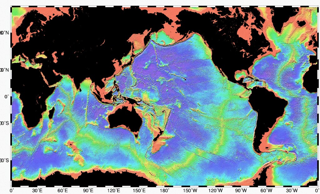
海洋的測深學從早期發展至今變化相當大。過去最簡單的測深工作是用繩子和重物手動進行。今日,聯合國海洋科學永續發展十年(2021~2030年)計畫支持的「海床2030」(Seabed 2030)專案,要利用先進的技術,在本世紀末前精確繪製全球完整的海床地圖。

水下無人載具(ROV)Deep Discoverer正在測繪一處海底熱泉。圖片來源:NOAA Office of Ocean Exploration and Research

整合全世界測深數據 且線上免費公開

日本慈善組織日本基金會(Nippon Foundation)和通用大洋水深圖組織(General Bathymetric Chart of the Oceans,GEBCO)主導海床2030大規模的水文測量工作。跨政府組織GEBCO的目標是要編制一份可靠的海底地形圖,詳細說明全世界海床的深度和形狀。

科學家們正在繪製中洋脊、海底火山、遺跡或水下海岸線、海底熱泉、古代冰川刻蝕出的冰磧和新的海底地殼等面貌。

收集來的所有數據都將被彙整進免費、公開的資料集「GEBCO Grid」中。海床2030專案的主要目標,是建立一個完整的GEBCO Grid資料集地圖,整合全世界的測深數據。

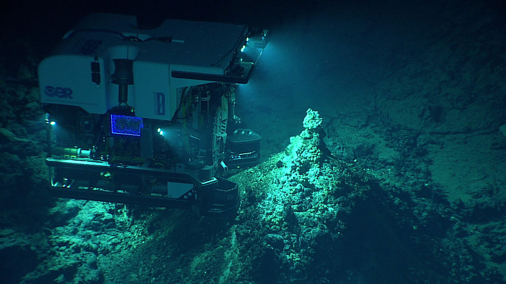
為了完成海底測繪,計畫參與者之一、美國非政府組織Global Oceans將改裝一種作業深度達6000公尺的Ocean Explorer 6000拖曳系統,搭載多波束聲納,未來也會支援該專案其他使用模組化自適應研究船(Modular Adaptive Research Vessel, MARV)的計畫。

MARV是由Global Oceans開發的一種作業模式,可調動模組化的工作空間和資源,供需要包船的科學研究計畫租用。這樣的模式利用世界各地大量閒置未用的海上服務船(Offshore Service Vessels, OSVs),這些船隊可以配備收集資料所需的研究工具,協助達成海床2030的目標。

Ocean Explorer 6000則是一款可以從MARV OSV部署的拖曳系統。加裝最先進的多波束聲納測深儀,並升級影像技術後,這種遙控載具將能夠渲染出更大面積的海底高解析度圖像。

紅色區域為大陸棚,黃綠色部分為中洋脊。圖片來源:NOAA/維基百科

不只更認識海洋生物 測繪全球海底地圖好處多

除了滿足人類的好奇心之外,全世界的海底詳細地圖還提供許多實際好處。例如幫助識別海底山脈的生態熱點,改善漁業管理政策和制定保育方針,以及加深人類對地表以下海洋生物的認識。

更詳盡的海底地圖能讓學界了解沉積物和營養物質的輸送、調節氣候的洋流,幫助判斷氣候變遷的影響。

此外,海底地圖還可以幫助人們預測不同地方的海平面上升情況,以便做好準備。準確的海洋測深圖有助模擬海嘯可能出現的地點,以及侵襲陸地的程度。

科技產業也將受益,因為準確的地形圖,對於鋪設海底電纜和開發波浪能轉換技術至關重要。波浪能轉換器收集傳入的波浪能,將海浪的能量轉化為可用的力學能或電能。

美國國家海洋暨大氣總署(National Oceanic and Atmospheric Administration, NOAA)海洋和海岸測繪綜合協調人查博(Ashley Chappell)說,測深圖有許多用途,「可用於海岸海洋科學、棲息地特徵、波浪模型、洪水模型、風能開發等等。」

完成該份地圖所需的大量資料,也要靠海洋研究組織、政府、海事行業和私人船家的協助,他們可以將資料記錄器連接到他們現有的聲納設備上。

其他收集的方式包括使用無人駕駛載具,以及讓船隻改變傳統的航行路線,這點在繪製位於南美洲和南極洲之間的德雷克海峽大部分區域時非常有用。

World’s Most Daunting Ocean Project: Mapping Entire Seafloor
TOKYO, Japan, January 15, 2022 (ENS)

Much has changed since the early days of oceanic bathymetry, the study of the seafloor, when simple soundings were taken by hand with a rope and weight. Today, an international effort led by Seabed 2030 is underway to precisely map the entire ocean floor by the end of the decade, an ambitious target that may be achieved with the help of advanced technology.

The Seabed 2030 project was unveiled in 2018 and has been endorsed by the United Nations for the UN’s 2021-2030 Decade of Ocean Science for Sustainable Development.

The massive hydrographic endeavor is spearheaded by the Nippon Foundation, a Japanese philanthropic organization, and GEBCO, or General Bathymetric Chart of the Oceans, an intergovernmental organization seeking to compile an authoritative map detailing the depths and shapes of the underwater terrain underlying all the world’s oceans.

The scientists are mapping features such as mid-ocean ridges, underwater volcanoes, relic or submerged shorelines, hydrothermal vents, moraine crests carved by ancient glaciers, and new ocean floor crust.

All data collected will be compiled into the free, publicly available GEBCO Grid. A primary goal of the Seabed 2030 project is to create a single map like this GEBCO Grid in which to consolidate all the world’s bathymetric data.

To accomplish the seafloor mapping, Global Oceans plans to make available its 6,000-meter Ocean Explorer 6000 towed system to be re-built with multibeam sonar.

The two organizations will explore opportunities to co-finance extended mapping on Global Oceans’ projects. And Global Oceans will support new Seabed 2030-related projects on MARV vessels, Costopulos said.

MARV, or Modular Adaptive Research Vessel, is an operational model developed by Global Oceans allowing for the mobilization of modular workspaces and resources for scientific research on time-chartered ships.

This model makes use of the massive fleet of Offshore Service Vessels, OSVs, that remain unused around the world which can be fitted with scientific tools necessary for data collection, contributing to Seabed 2030’s goal.

The Ocean Explorer 6000 is a towed vehicle which can be deployed from a MARV OSV. Following its reconstruction with the state-of-the-art Multibeam Echo Sounder and additional upgrades to its imagery technology, this remotely operated vehicle will be capable of rendering high resolution images of broader sections of the seafloor.

Beyond satisfying human curiosity, a detailed map of the world’s ocean floor offers many practical benefits. A comprehensive map of the benthic world would help us identify ecological hotspots which are typically present at seamounts. This knowledge would allow for better management of fisheries and could direct conservation efforts.

Understanding the underwater topography will also further human comprehension of marine life below the surface.

Better ocean floor maps would also enhance our understanding of oceanic currents which transport sediments and nutrients and regulate the climate, which will determine how drastic the effects of climate change are.

They could also help us to predict how sea-level rise will occur in different places, allowing us to better prepare. Accurate bathymetric maps of the oceans could allow us to model where and how hard tidal waves are likely to strike land.

The technology sector also stands to gain as an accurate topographical map is essential for laying submarine cables and in the development of Wave Energy Conversion technology. Wave energy converters harvest incoming wave energy, changing the energy of a moving ocean wave into useable mechanical or electrical energy.

Ashley Chappell, integrated ocean and coastal mapping coordinator for the National Oceanic and Atmospheric Administration, explained the many uses for bathymetric maps, saying, “Data is used in coastal ocean science, habitat characterization, wave models, flooding models, wind energy development, all kinds of things.”

Collecting the enormous amount of data necessary to complete the map depends on efforts by marine research organizations, governments, maritime industries, and private boat owners who can attach data loggers to their existing sonar equipment.

Other strategies for collecting data include the use of uncrewed vehicles, and switching traditional routes taken by ships, which was effective in mapping much of the Drake Passage between South America and Antarctica.

※ 全文及圖片詳見:ENS

作者

姜唯

如果有一件事是重要的,如果能為孩子實現一個願望,那就是人類與大自然和諧共存。

林大利

農業部生物多樣性研究所副研究員,小鳥和棲地是主要的研究對象。是龜毛的讀者,認為龜毛是探索世界的美德。