最新衛星地圖集 見證非洲環境大變遷 | 環境資訊中心
國際新聞

最新衛星地圖集 見證非洲環境大變遷

2008年06月13日
摘譯自2008年6月10日ENS報導南非、約翰尼斯堡;朱以方編譯;蔡麗伶、禾引審校

對比2005年1月(左圖)與2006年1月的空照圖,可以知道非洲環境正面臨極大的變遷。圖片來源:NASA
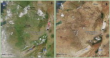
非洲各國的環境部長6月10日聚集在約翰尼斯堡,聽取一項最新的地圖集簡報。這份新的地圖集是利用上百張衛星影像和地圖來呈現過去35年來,非洲大陸的改變。有些是被視為負面的改變,例如冰河融解、城市與郊區取代了森林、野生動物消失變成珍饈。但是也有些改變是好的,包括因為較完善管理措施而逐漸復育的森林與稀有物種。

這個會議由南非總統姆貝基(Thabo Mbeki)開啟。姆貝基同時主持非洲環境部長會議。這個地圖集有超過300張的衛星影像,而這些影像來自非洲各國,超過100個地點所拍攝。這個地圖集是由位於肯亞奈洛比的聯合國環境署所編輯完成的。

然而,有些非常危急的環境問題存在著,而這個地圖集也充份呈現出來。自從1975年以來,在剛果共和國的北部,伐木廊道逐步擴大造成道路的同步擴展。而新的道路將大量的交通人潮帶進這個生態豐富的雨林,甚至激勵了野生動物肉品的商業交易,即所謂的叢林餐。

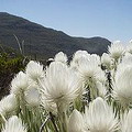
在南非開普敦的北界,從1978年以來,很多原生的芳百氏小灌木植被已經被農田和郊區發展所取代。

在開普敦的植物區,芳百氏小灌木約佔所有植物種類的80%。芳百氏小灌木的多樣性甚至比熱帶雨林還豐富。這個區域有超過9000個品種,其中約有6200種是其他地方都找不到的。

地圖集中的衛星影像也顯示,在蘇丹西部的傑貝馬拉山麓區,這個區域的環境非常脆弱,有許多樹木和灌木叢都已經消失。這些植物之所以會消失,部份因為來自鄰近國家北達佛的人民為了躲避乾旱與衝突,紛紛逃難到本區,以致人口增加造成物種消失的後果。

位於開普敦附近的芳百氏小灌木。圖片來源:Damien du Toit保育管理的正面效果也可以在衛星影像中看到。新的政策與執法的改善已經減少肯亞山森林的非永續開發行為,肯亞山正好是重要的集水區與水力發電的所在。

針對植林與保育林的農民倡議行動也使得尼日塔郝華省的土地恢復生機。最近的一項研究顯示,與1970年代相比,在尼日南部的三個省份的森林覆蓋率成長10-20倍之多。

衛星地圖集的主要發現與關切重點

地圖集顯示,非洲每年喪失超過4百萬公頃的森林,這是全球平均伐林速率的2倍。全球森林年消失率最高的前10名國家,有6個就在非洲。非洲森林的年平均消失面積是4萬平方公里(或者0.6%),而最嚴重的森林伐木區域則發生在森林最茂密的國家。

伐林、土地使用改變成農田或住宅、森林野火、為了薪材及木炭所進行的伐木、社會動盪不安等都是非洲砍伐森林的主要因素,多數都是來自人口成長的壓力。雖然非洲只貢獻全球4%的二氧化碳排放,但是,跟世界上其他地區的人民相比,非洲的居民將更可能遭受全球暖化所帶來的更多損害。

所有的地圖集都沒有著作權的限制,完全可以免費使用。個別的衛星影像、地圖、圖表和相片都可以在這裏下載。

New Atlas Captures Changing Face of Africa's Environment
JOHANNESBURG, South Africa, June 10, 2008 (ENS)

Environment ministers from across Africa gathered in Johannesburg today were presented with a new atlas that uses hundreds of satellite images and maps to show how the continent has changed over the past 35 years. Some changes are viewed as negative - glaciers melting, cities and suburbs replacing forests, wild animals disappearing into cooking pots - but others are seen as positive - forests and rare species recovering due to better management practices.

Launched by South African President Thabo Mbeki, who is hosting the African Ministerial Conference on the Environment, the atlas features over 300 satellite images taken in every country in Africa in over 100 locations. It was compiled by the UN Environment Programme, UNEP, based in Nairobi, Kenya.

Yet, there are critical environmental problems, and the atlas describes them. In the northern Democratic Republic of the Congo since 1975, widening corridors of deforestation have accompanied expanding roads. New roads threaten to increase traffic into this biologically rich rainforest and further fuel the commercial trade in wild animals for meat, known as bushmeat.

In South Africa, at the northern edge of Cape Town, much of the native fynbos vegetation has been replaced by farms and suburban development since 1978.

Fynbos make up 80 percent of the plant varieties in the Cape Floristic Region. The diversity of fynbos plants is greater than that of the tropical rainforests, with over 9,000 species of plants occurring in the area, around 6,200 of which occur nowhere else.

Satellite images in the Atlas show the loss of trees and shrubs in the fragile environment of the Jebel Marra foothills in western Sudan. These plants are disappearing as a result of population growth partly due to an influx of refugees fleeing drought and conflict in neighboring Northern Darfur.

Positive signs of protective management also can be seen in the satellite images. New policies and improved enforcement have reduced unsustainable exploitation of the forests of Mount Kenya, which is a crucial area for water catchment and hydro-power generation.

Farmer initiatives focusing on the planting and protection of trees have led to land revitalization in Tahoua Province, Niger. A recent study shows there are now 10 to 20 times more trees across three of Niger's southern provinces than there were in the 1970s.

Main Findings and Key Concerns

Africa is losing more than four million hectares of forest every year - twice the world's average deforestation rate, the atlas shows.Of the 10 countries in the world with the largest annual net loss of forested area, six are in Africa. Africa loses an average of 40,000 km2, or 0.6 percent, of its forests annually, with the greatest losses occurring in heavily forested countries.

Logging, land conversion to agriculture and settlements, wildfi res, cutting for fi rewood and charcoal, and civil unrest are the primary causes of deforestation in Africa; many of these pressures are driven by population growth.Although Africa produces only four percent of the world's total carbon dioxide emissions, its inhabitants are likely to suffer more from the consequences of global climate change than people in other parts of the world.

All the materials in the Atlas are non-copyrighted and available for free use. Individual satellite images, maps, graphs and photographs can be downloaded from http://na.unep.net/AfricaAtlas

全文及圖片詳見:ENS

作者

蔡麗伶(LiLing Barricman)

In my healing journey and learning to attain the breath awareness, I become aware of the reality that all the creatures of the world are breathing the same breath. Take action, here and now. From my physical being to the every corner of this out of balance's planet.