 經過一年合作,美國新墨西哥州的桑迪亞國家實驗室(Sandia National Laboratories)與伊拉克的工程師合力為伊拉克建立了一個地面水的模型,伊國政府將可利用此模型作水利與土地規劃。
這模型跨越了土耳其、敘利亞和伊朗的河流流域,流域內包括了農業、城市與工業用地、高鹽分地區,還有伊拉克南方美索不達米亞沼澤地的生態復育區。
桑迪亞實驗室的巴索(Howard Passell)表示:「伊拉克很清楚他們國家長期的穩定與安全,乃建基於乾淨的水源,包括農業、都市與工業用水,而我們很有幸在此時伸出援手。」
這個計畫由美國的「伊拉克移交協助辦公室」所資助,已在過去一年間舉辦了三次為期五天的工作坊。
今年6月,所有人員在伊斯坦堡會晤,由伊拉克籍的工程師向三位水利部官員報告計畫成果,與會人員包括了桑迪亞實驗室的團隊、水利部的工程人員、美國大使館的特約顧問和聯合國教科文組織的水利專家。
2007年11月與2008年2月,工作人員在約旦的安曼舉行工作坊,第一個工作坊主要讓伊拉克人熟悉軟體,並考慮各種資源利用系統彼此間如何相互聯繫。
到了第二個工作坊時,桑迪亞實驗室的研究人員從得到了有用的數據與資料,藉此建立了第一個草擬的模型,伊拉克同事也在學習中建立了部分內容,然後到了第三次會議結束時,他們已經向水利部的高階官員報告成果。
伊國境內的底格里斯河與幼發拉底河來自上游的土耳其,而這跨國的水流量是模型裡的一個關鍵變數。負責模型中跨國模組的雷諾說:「伊拉克的地表水深受上游國家水利建設與用水的影響。」
長久以來,土耳其與敘利亞並不是這水的主要使用者,但隨著這兩個國家發展更多儲水用水的容量,對伊拉克來說這是個隱憂。如同伊拉克在兩江平原地處下游,美索不達米亞沼澤地也在伊國的更下游受到威脅,這濕地是在阿拉伯灣附近重要的淡水沼澤生態系。
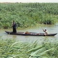
 這片溼地曾有8000平方公里之大,且孕育了沼澤阿拉伯人的古老文化,但現在因為上游用水,溼地面積正逐漸縮小。因為當時海珊(Saddam Hussein)的敵人躲在溼地區,他曾在90年代將溼地部分地區排水乾燥,並威脅要增加上游的用水量。現在溼地面積僅存5000平方公里。
在桑迪亞團隊中負責溼地的克里斯(Geoff Klise)說道:「這溼地長期以來在文化、歷史與經濟上都非常富有且多樣,現在漸漸枯竭,一半是意外,一半是人禍。」
這模型將內建於一個名為Studio Expert的商業軟體,由Powersim公司發行,軟體將包含短期模型預測、簡單操作的使用介面還有即時的繪圖功能。
桑迪亞的工作人員說伊拉克地面水計畫的第二期資金將在本月到位。
A working computer model of Iraq's surface waters is the outcome of a year-long collaboration between scientists from Sandia National Laboratories in Albuquerque and Iraqi engineers and modelers. The model is intended to inform a national water and land planning effort by the Iraqi government.
The model includes transboundary river flows from Turkey, Syria, and Iran, along with agriculture, municipal and industrial uses, salinity, and restoration of the ecologically sensitive Mesopotamian Marshes in southern Iraq.
"The Iraqis recognize very clearly that the long-term stability and security of their country depends on the availability of fresh water for agriculture and for municipal and industrial uses," says Sandia researcher Howard Passell. "We are grateful to have the opportunity to help."
The project, funded by the U.S. Department of State's Iraq Transition Assistance Office, included three five-day workshops over the past year.
In June, all the project participants met in Istanbul for a demonstration of the model by the Iraqi engineers to three of their directors from the Iraq Ministry of Water Resources, MoWR. The participants included the Sandia team of Passell, Jesse Roach, and Marissa Reno, four engineers from the MoWR, a State Department contractor from the U.S. embassy in Baghdad, and a water program manager from UNESCO.
The first two workshops in the Iraq project took place in Amman, Jordan in November 2007 and February 2008. The initial workshops focused on helping the Iraqis learn to use the software and think about how the different systems associated with their resource issues are interdependent and interconnected.
By the time of the second workshop, the Sandians - with data and other information from the Iraqis - built a first draft of the model. The Iraqis used their growing skills to build part of that version of the model. "At the end of the third workshop, our Iraqi colleagues presented the model to three high-level Iraqi Ministry of Water officials.
One of the critical drivers in the model is the flow of water from the headwaters of the Euphrates and Tigris rivers in Turkey across the border to Iraq.
"Surface water in Iraq is affected by infrastructure development and water operations in upstream countries," says Reno, who built the transboundary module in the model.
"Historically, Turkey and Syria were not major water users, but now both countries have developed the capacity to store and use more, and that is a major concern to Iraq," she said.
As Iraq is at risk as the downstream user in the Tigris-Euphrates system, so are the Mesopotamian Marshes at risk as the downstream user in Iraq. They are a crucial freshwater wetland ecosystem in the Arabian Gulf region.
Populated by Marsh Arabs with their ancient culture, the southern marshes once covered about 8,000 square kilometers, but water uses upstream have gradually reduced the marsh area.
Saddam Hussein partially drained them in the 1990s when his enemies hid there, and they are threatened by increasing upstream water use in the future. Now the marshes cover about 5,000 square kilometers.
"The marshes, which are culturally, historically, and economically rich and diverse, have started to dry out - partly by accident and partly by design," says Geoff Klise, the Sandia team member who built the marsh module.
The model was built in a commercially available system dynamics modeling platform called Studio Expert, produced by Powersim Inc. It features short run times, user-friendly interfaces, and real-time graphical output.
Sandia officials say new funding for phase two of the Iraq surface water project is expected this month.
全文及圖片詳見:ENS


